Sunday, October 31, 2010

Geological Processes

Coastal Communities

The communities and cultures of Nanwalkek, Alaska, the Hawaiian Islands, and New Bedford, Massachusetts all share a lifestyle fundamentally dependent on the sea. Particularly in the Aleutian and Hawaiian communities, culture teaches to respect and honor nature and to use everything harvested, right down to fish skin and octopus ink.
 

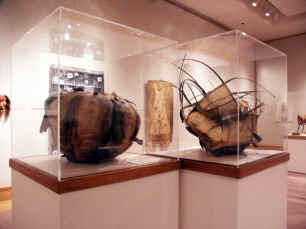
Incredible fish skin baskets from Art Scene AK

New Bedford and other East Coast fishing communities were built much more recently in history, and as a result, the cultures that have developed there are “melting pot” cultures – families from cultures as diverse as Portuguese to Norwegian relocated there in the early 1900s in order to find work. Their cultures are still distinct, but over time, some of the customs have been melted together, and many modern day East Coast natives have a rich heritage of a combination of cultures.


Volcanoes are simultaneously violent and destructive and awe-inspiring and beautiful forces that demand respect and dictate lifestyle and culture for communities that live anywhere near them. Like other natural forces, volcanoes wait for no man.

Growing up between Alaska and Hawaii, I have a lot of jumbled memories of times that volcanoes dictated the lives of my family and families in our communities.

Mt. St. Helens eruption, 1980

The 1980 Mt. Saint Helens eruption in Oregon sent clouds of volcanic ash pouring down on our Kenai Peninsula home, burying, my mom swears, our front yard in several inches of dust and blowing up more than one vacuum cleaner.


The continuous eruptions of the Kilauea Volcano on the Big Island in the 1990s covered roads we drove on every day, ate the homes of some of my elementary school buddies’, and added acres of new land to our island on the Kalapana side.


Just last year and the year before, the relatively mild eruptions of Mt. Redoubt, across the Bay from my current home, brought wonderful opportunities for online volcano-monitoring in my middle school science classes.


Stories are important to culture because through them, people pass on an oral tradition rich in history. They allow people to explain natural events that were – before (and even after) scientific explanation – very scary.

Western science offers other explanations for natural events and opportunities for further study. It expands on ideas indigenous people have been observing for hundreds of years.

However, when it ignores the sacred and sustainable aspects of culture in the name of progress and money - such as what is happening at the Mauna Kea observatories on the Big Island and at the possible site of Pebble Mine in Bristol Bay, Alaska - it becomes a negative, destructive force.

Geological Unrest: Earthquakes, Volcanoes, Hot Spots, Tsunamis


Earthquakes and Tsunamis
As the earth’s 29 tectonic plates continually shift and slide on the lithosphere, kinetic energy in the earth’s crust forms seismic waves similar to sound waves.

Use slinkies to demonstrate seismic waves

I have demonstrated these quickly to students of various ages using slinky, which can be compressed in different ways. P, or primary waves, which shake in a forwards-backwards motion, can travel through any type of material, including liquid. They arrive at the focus of an earthquake first because they travel about twice as fast as S waves.

S, or secondary, waves, which move side-to-side, travel more slowly and are thus felt after P waves. They bring much more violent destruction. The most destructive type of wave are surface waves, which travel like water waves along the earth’s surface.
 

The 1964 Alaskan earthquake was caused by the Pacific Plate subducting underneath the North American plate, where it was temporarily stuck.  Valdez was sitting on top of the subducting plate, so when the stress was released, it was affected most greatly by the five minutes of violent shaking that occured on Good Friday, 1964.

Sediments saturated with ground water liquefied because of the shaking, causing 98 million cubic yards to break off and tsunamis waves as high as 30 feet. The ground dropped almost nine feet at the harbor and shifted 30 feet sideways in town.

One oil stove caught fire and the flames quickly spread to other tanks. 32 people died, and the town was evacuated by everyone except people cleaning up the debris and rebuilding the town. Eventually, Valdez was reconstructed on more solid ground three miles away.

Earthquakes often cause tsunamis like the one that began in Valdez in 1964. On July 9th, 1958, around 10:15 in Lituya Bay, which is in Southeast Alaska, an earthquake in the Crillion Inlet caused a landslide that generated a wave of 1,719 feet!

Volcanoes in the Aleutian Trench and Hawaiian Island Chain
The Aluetian Trench, which  is about 2,448.95 miles long, is on a convergent boundary, where the Pacific plate is subducting underneath the North American plate. The Aleutian Archipelago is a chain of more than 300 islands born of volcanic activity that extend westward about 1,200 miles off the Alaskan Peninsula. 
Many earthquakes occur here because of the kinetic energy that is building up as the earth’s crust moves. Most earthquakes, however, occur at transform boundaries because as two plates slide past each other, they bump over and over again, and the friction causes kinetic energy, which is released by seismic waves.           

Click here for screen shots of the Aleutian Trench and the Aleutian Archipelago.

Hawaii Island/Emperor Seamount chain, which starts at the Big Island of Hawaii and continues on until the chain meets the tip of the Aleutian trench, is approximately 3,800 miles long. The Hawaiian Islands are different from the Aleutian Islands because they are being created by hot spot volcanoes, as opposed to the subducting of a plate in the deep-ocean Aleutian trench.
Click here for screen shots of the Hawaii Island/Emperor Seamount chain.

Creation of the Aleutian Islands


The northwest-moving Pacific plate is subducting beneath the North American plate. As the plate descends, the temperature and pressure melts the rock of the crust, creating magma, which erupts eventually out of the more than 40 volcanoes in Alaska.

Creation of the Hawaiian Islands
As the Pacific plate travels northwest at about nine centimeters per year, it moves over a hot spot in the earth. The extreme heat may come from radioactivity at the earth’s core. It heats magma and convection currents cause this to rise and break through lithosphere, slowly erupting out of volcanic vents or side-vents and building islands from as far as 30,000 feet below the ocean’s surface over thousands of years.
 

As the plate continues to move, eventually away from the hot spot, the volcanoes eventually become dormant.

Like the Aleutian Island chain, the Hawaiian Island chain it is not straight; I think this is because of plate tectonics. The Hawaiian islands were and are currently being created by hot spot volcanoes. As the Pacific plate travels northwest over the hot spot in a curved shape, the  islands are created following that path.

The Island of Hawaii and the in-construction island of Loihi (still 3,000 feet underneath the water to the east of the Big Island) are currently the only islands whose volcanoes are not dormant; these volcanoes are still over the hot spot.

Extend
Google Earth is an incredible resource for teaching science. As you and your class “fly" to different areas on the globe, students become more engaged because they can really see the area and topic being discussed. Earthquakes and other geological events that happened in the last hour are directly relevant to their lives – and that gets their attention! This morning, I was able to see that on Kodiak and near Cooper Landing, there were 2.9 magnitude earthquakes.

Evaluate
I think Google Earth is extremely valuable in teaching earth science because seeing things in real time and real space that are directly relevant to students' lives gets them interested and engaged.

The ruler feature allows students to get a concrete idea of the special relationships between places they are studying and the place they are standing. When students are able to use technology to “see things” like this, they want to pay attention to the rest of the lesson because they care about the information.

Then, when teachers use other digital media, like videos  and interactives from Teacher’s Domain, You Tube, and Discovery Education (as well as other resources), to explain and demonstrate types of geological events, students already have a link in their schema – they understand that these things are really happening on the globe near them. Some may even seek out other resources.

Monday, October 25, 2010

Anthropological Geoscience: Athabascans in the Interior

As I explored the home of the Alaskan Athabascan people –  the Yukon River as it winds from Canada through the Alaska Range, the Alaska Peninsula, and eventually and out to the Chukchi Sea –  I can see how anthropologists and historians were able to divide the approximately 11,000 Alaskan Athabascan people at time of contact into three main groups – the riverine groups, upland groups, and Pacific groups – based on the regions they inhabited and the hunting, fishing, and gathering patterns they followed (Langdon, 81).

Langdon, Steve J. The Native People of Alaska: Traditional living in a northern land.
Anchorage: Greatland Graphics, 2008. Print.

Landscapes of Life


The concepts of physical landscapes and environment and culture are difficult ones to separate. For all of us, the environment we live in shapes our culture, and as a result, our culture must adapt to changes in that landscape, as well as changes in neighboring cultures. As Teslin Tlingit First Nation representatives Juanita Kremer and Corrine Marion Sheldon recognize in On the Yukon River, the Tlingit people have always been taught that they were an integrated part of land and water. In Living from the Land and the Sea, Paul Marks points out that the Tlingit, by living their subsistence lifestyle in accordance with the seasons and moon phases, live in intricate interdependence with the landscape. As stewards of land, it is their responsibility to sustain the food harvest and be part of management. Although these people recognize that their grandchildren have a host of career opportunities available to them in the modern world, they want them to have the option to come out and make living from river; thus, they recognize that, as scientists and stewards, they must work together to minimize changes in environment and landscape such as increasing temperatures in rivers, decreasing water levels, proliferating beaver dams, and a rising in parasite populations due to warmer waters. All these negatively affect salmon population and thus affect subsistence way of life. Salmon are not the only resource that are affected by change to landscape – migratory patterns of other animals ranging from birds to game to other fish are shifting, and the species are sometimes even disappearing altogether, because of changing landscapes and habitat.

Also important to a comprehensive view of science is an understanding of tectonic forces, which continually move and reshape the eight major plates that make up the earth’s rigid crust and more pliable lithosphere. Ultimatly, these forces reshaped the earth’s landscape from the supercontinent Pangea 200 million years ago  to the seven continents it is today. As is discussed in Tectonic Plate Movement in Alaska, our state’s location at a major boundary makes it a unique and active geological place to live. The less-dense basalt oceanic crust of the Pacific place undergoes subduction beneath the denser granite continental crust of the North American plate at a rate of about five to seven centimeters per year, causing the Aleutian Trench to widen, and the old, denser crust to subduct back into the earth’s mantle, where it will be warmed into magma and eventually recycled through volcanic mountains in the Aleutian Range and Aleutian Islands, or possibly even a mid-ocean trench somewhere else on the globe. The subduction of the Pacific plate also pushes up on the crust and lithosphere that form the Atlantic plate, causing crust-crumpling earthquakes and building mountains. Through this cyclical recycling process of plate tectonics, old geological structures are decimated and new ones rebuilt, affecting, at a slow rate, all landscape and biological and cultural life on earth. As Richard Glenn: Iñupiaq Geologist pointed out when he called ice a geologist’s “dream come true,” ice is a sometimes studied as its own geological rock formation because it undergoes these same processes as rock does in plate tectonics, but at a faster, and more observable, rate.


Rural Alaskan students face the unique challenge of becoming skilled in two sometimes differing ways of knowing, Native and Western, and then integrating what Richard Glenn: Iñupiaq Geologist  refers to as “two flashlights shining down the same path” to create one understanding of earth science.  This daunting task becomes more bearable for students when we, as teachers, endeavor to understand the interconnections between Native ways of knowing and Western scientific perspectives and then teach them to our students in an integrated manner. On their own, both ways of knowing the science of the landscape are valuable, but, as Glenn acknowledges, when processed and understood together, “the two can be the key to solving some of today’s complex problems.”  Chevak native teachers teach their community members, as well as visitors such as the teachers that came to visit, the subsistence way of life through demonstration and hands-on time to practice. Whether in a classroom or out in the landscape, allowing hands-on time for experience and practice is a valuable way to allow students to have authentic learning experiences that will become permanent parts of their developing schema. There are many resources to help teachers, especially those teachers not Native to Alaska, to connect to the powerful environment that shapes the culture of Alaska Natives and Westerners who call the incredible landscape their home. Many of them I have already mentioned, including Center for Alaskan Coastal StudiesAlaska Sea Life
Center , Pratt Museum, Alaska Seas and Rivers Curriculum, and Montery Bay Aquarium. As is demonstrated by the interactives on DiscoveryEducation.com and Mountain Maker, Earth Shaker, Tectonic Plates, Earthquakes and Volcanoes, and Rock Cycle Animation, technology can plan a vital role in allowing students to have hands-on experience with concepts they otherwise may have trouble comprehending. I used another good hands-on demonstration of the rock cycle last year, too. 

Additionally, here are some basic Power Points I developed for teaching Plate Tectonics to my 6th graders. They are part of a unit, but these are the ones that apply to this week's module. 

Wegner's Hypothesis

Seafloor Spreading

Digging the Real Dirt on Plate Tectonics
  
Plate Boundaries

Volcanoes

Rock Cycle


For all of us, Native Alaskan and Western alike, a sense of belonging and a sense of place is crucial to our development and to feeling comfortable in our own skin. In more urban settings than Alaska, where the connection to the landscape and the environment is being lost – where students literally don’t know and don’t think about where their food and shelters come from (other than the store) – a powerful part of the sense of self is lost.  Consequently, I believe it is more difficult for learning to occur because that schema of culture and environment is not there, and students cannot connect their new learning, whether it be in science or math or language arts or social studies or health, to a broader and more holistic body of background knowledge.

Sunday, October 17, 2010

Homer, Alaska, my Birthplace, on Google Earth

The Sterling Highway ends at the Spit in Homer, Alaska, the town in which I was born and in which I currently live. Homer is bordered by Kachemak Bay on one side. Across this body of water are many mountains and nine glaciers, including the Grewgink Glacier, which we can see most clearly and access most easily from Homer. Behind Homer flows the Anchor River. There are many smaller creeks feeding off this river.

I cannot figure out how to save the images to my computer and reupload them here. Here are some links to a few good images.

Looking at the Kenai Peninsula from a little higher up.

Just our town. You can see "the Spit" extending out into Cook Inlet.

I was born at a Birthing Center on the corner of Pioneer Avenue and Bartlett.
Now I live just up the street. I grew up on Northfork Road, though.

Teaching Universal Unification


Native Alaskan ways of knowing and Western scientific knowledge share a common, grounding principle – that everything in the universe is cyclical and fundamentally unified.  They are also both centered around hypothesis and repeated observation-based investigation. This can be seen in the Venn diagram adapted by Prof. Good from Sidney Stephens' Handbook for Culturally Responsive Science Curriculum.
The Inuit see this connection in Sila, the “deity of sky, wind, and weather.” The Teacher Domain video People of the Arctic translates the word to “temperature and atmosphere,” but explains that it means, in essence, the “intelligence of the world.”  
As the article “Traditional Knowledge Systems in the Arctic on the Alaska Native Science Commission’s website points out, Western science removes the “sacred” from its idea that the universe is fundamentally interconnected, but it still describes a unified “Earth System” – a biosphere, hydrosphere, lithosphere, cryosphere, and atmosphere that are united and interdependent. Like Sila, this Western system “controls everything that goes on in one’s life” – and in all life, for that matter. In the earth system, the oceans absorb and are heated by energy from the atmosphere, which causes heat and moisture to rise from the ocean, driving weather patterns that affect the cyclical melting and freezing of the cryosphere. Simultaneously, the energy transfer that takes place in the reoccurring process of plate tectonics drives the rock cycle and all changes in the lithosphere. All this constantly recycled water, rock, and energy, of course, affects the whole biosphere - all life on Earth. Any change in climate or geography, no matter how minute, tug at single parts of food chains, and ultimately produce widespread transformation in all life on earth (Earth as a System).
Although the fundamental principle of a unified universe is shared by Native Alaskans and Western scientists, there are also differences in the two systems of knowledge.  The article “Traditional Knowledge Systems in the Arctic points out that Native Alaskan knowledge is significantly more holistic, intuitive, and subjective than that of the Western world, particularly because it includes the “sacred.” Additionally, the Native knowledge base has been acquired perhaps over thousands of years and does not seem to change as rapidly as Western scientific knowledge, which has been drastically altered since the 1600s, when, to everyone except Copernicus, Galileo, and their small group of followers, “nothing could be more obviously than the fact that the earth [was] not moving” (Galileo: Sun-Centered System).
The ways knowledge is communicated and applied also vary between Native and Western culture. Native knowledge is shared through metaphor and story telling and is practically applied in daily life –  such as in the collection of driftwood and the harvesting of edible plants, sod, animal skins, clams, and pink salmon by the Chevak residents in The Spirit of Subsistence Living, – whereas Western knowledge is communicated through relatively objective written records. And the resulting theories are not, at least first, particularly applicable to the average person’s everyday life.


For all of us, Native Alaskan and Western alike, the environment and culture we grow up in has a profound impact on how we learn. When we are able to make a connection between something new we are learning and something already in our schema (because it is an integral part of our environment or culture), the “click” happens seamlessly and learning takes place almost effortlessly. It is important to understand and be able to think in "both ways" because then learning becomes easier for us and we can connect of many different types of people.
Lucky children discover their culture and heritage from their parents, extended families, and community elders. Then we teachers come in, and with our carefully-planned integrated units that involve experts (especially Native community members and elders), we allow students to experience state learning standards in a way that is directly environmentally and culturally relevant to them. This way, the knowledge really sticks – and we teachers can rest assured not only that that our students will have the knowledge they need to do well on standard-based assessments like the SBA and Terra Nova, but more importantly, that they will be inspired to seek out more such knowledge because they care about it.
Unfortunately, there are many students who are not blessed with the familial and communal resources necessary to develop a solid understanding and appreciation of culture. Because this knowledge is crucial to becoming a good problem solvers, wise decision makers, and consequently, responsible citizen – everything we  teachers ultimately want for our students – it becomes necessary that we support students’ families and communities in helping students become more culturally knowledgeable.


When Anchorage assistant science teacher Dustin Madden was able to connect to his students through common heritage of subsistence lifestyle and love of dance, his message about the role good science plays in the preservation of the Native subsistence lifestyle and environment reached his students (Dustin Madden: Science Teacher).

Similarly this year, I was able to engage all my sixth graders during their nutrition unit by guiding them in exploring ways to make healthy food choices for their bodies as well as responsible food choices for our planet by sharing my experiences gillnetting in the sustainable salmon fisheries of Cook Inlet and Bristol Bay. Parents also involved in the fishing industry came in to help us in our studies as well. These experiences were relevant to the kids because the fishing lifestyle is familiar to them – they, or someone in their family, live it. In essence, the information they learned actually mattered to the students because it related to their physical environment and their culture.
Student exploring the many factors that affect the salmon lifecycle in Alaska through a game.
In an integrated social studies and geometry unit, my 2nd and 3rd graders and I, guided by a community elder, looked at some different reoccurring patterns in Native art. We examined a variety of different samples, picked out the ones my students found most intriguing, and then researched their backgrounds. I then showed them how traditionally, Native artists used their body parts (knuckles, fingers, palms, wrist to elbow, etc.) to make measurements to create the perfect, symmetrical shapes. My students see these patterns on a regular basis; learning about them in a more in depth way allowed the students to appreciate the patterns from a cultural and mathematical standpoint.
 
There are many reoccurring symmetrical shapes in Native art.
In an integrated biology and social studies unit, the 6th and 7th grade students and I  learned about the most common species of fungi and plants in our Kenai Peninsula bioregion, their cultural significance and traditional stories that involved them, and how they are involved in the food webs and interrelatedness of life in the bioregion. The Alaska Center for Coastal Studies and Islands and Oceans Center helped us with these studies.  This information actually mattered to the students because it related directly to their physical environment and their culture.

These are three examples of hands-on learning experiences that take place right in our local environment. They allowed students to make a connection between something  already in their schema (because they experience it in our everyday lives) and something new they learned in school; as a result, learning took place with less effort and students were inspired to seek out more knowledge on these topics.
A Few of the Resources for Teaching Culturally Responsively in Alaska that I LOVE!
Center for Alaskan Coastal Studies has some incredible resources for teaching about Alaska's water systems and the aquatic biome in a holistic, culturally inclusive way. They also have kits available for check-out (I think you can check these out by mail), including kits that incorporate Native art and Western science.

 Alaska's only public aquarium offers an abundance of resources for educators. The programs they do here are great for all ages. They also work with the Forest Service Education Department at Exit Glacier, which has its own great collection of culturally rich programs. They both do distance education.
Pratt Museum
 The Pratt has many wonderful scientific and cultural displays. Their education department does distance learning and has kit checkouts.

Alaska Seas and Rivers Curriculum
This is a comprehensive resource for teaching Alaska science content standards and GLEs in a way students will engage and connect with your lessons. Check out the "partnership" link to learn more about incorporating elders in your classroom. There is also some useful information on conservation and stewardship. 

Monterey Bay Aquarium also has some great resources, especially the songs. They are not all Alaska-specific, of course. There is a great video on conservation with walruses having to adapt quickly because their floating ice homes are melting.

Sunday, October 10, 2010

Some photos from the 2010 salmon season on the F/V Selma in Bristol Bay, Alaska.

Fishing on "the line."
Some of our eccentric friends.
My sister, dad, and me on the back deck.
A great day!

Lila Loves Bristol Bay, Alaska

The Bristol Bay watershed, 50,000 square miles bounded on the west by the Bering Sea and on the north, east, and south by the Ahklun and Kuskokwim Mountains and the Alaska and Aleutian Ranges, is a wild, tough, and biologically and geologically rich country that has sustained human life for the past 9,000 years with its plethora of renewable resources (Branson, 1).  The pristine fresh waters of Bristol Bay’s rivers and lakes support five species of Pacific salmon, with sockeye or red salmon being the most plentiful species (“Bristol Bay and the Sailboat Fishery”).  Salmon has been the backbone of nearly all life in the Bristol Bay region for hundreds of years.  They supply large mammals, including humans and bears, with energy and stamina.  Their decaying bodies fertilize the aquatic plants that nourish other fish, insects, ducks, and geese and the trees and shrubs that feed moose and beaver.  Since 1867, when commercial gillnetting began aboard sailboats in Nushagak Bay, salmon has provided the livelihood and income of hundreds and hundreds of people and families in the fishing, canning, and marketing industries (“Bristol Bay and the Sailboat Fishery”). 
            My family is one of those supported by the yearly Sockeye run of Bristol Bay. Naknek/King Salmon, Dillingham, Egegik, and Ugashik, Alaska, are important places to me because, of course, of the monetary support they provide my family, but much more importantly, because Bristol Bay is a place where we come together each year to share the adventure of a new fishing season.  Over the years, we have acquired a diverse and eccentric group of fisher friends, and I greatly look forward to our reunion each June.

Bristol Bay Links
Map of Bristol Bay

If you'd like to learn more about early conservation efforts, read this paper I wrote last spring.
Salmon Conservation Efforts in Bristol Bay, by Lila Little


Archival photos of the early Bristol Bay salmon fishery
There are many more available in Branson's book, cited below.

My mom sells our salmon in Oregon, bringing the family business full circle.
Fish Queen

Work Cited

Branson, John B. The Canneries, Cabins and Caches of Bristol Bay, Alaska. Lake Clark National Park and Preserve: United States Department of the Interior, 2007. Print.

Bristol Bay and the Sailboat Fishery.” Alaska’s Past – Regional Perspectives. Southwest Alaska
,  2004. Web. 10 October 2010.

Welcome!

Welcome to Lila's Blog! 


My intention here is just to have a place to post stuff... I'm sure it will end up an eclectic collection of artifacts from my life: teaching resources, beautiful Alaskan landscapes, poetry, science, fisheries tidbits, recipes, my kids and homelife... who knows what else! Keep reading if you want to find out...